
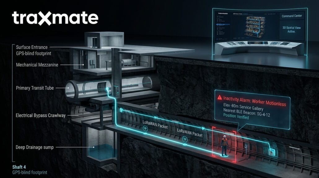
A contractor trips over an exposed conduit in a service gallery 80 meters below street level.
He knocks his head on a steel rib. He loses consciousness.
Above ground, the safety supervisor monitors a flat AutoCAD screen. The software shows a dot near Shaft 4.
Which elevation?
Shaft 4 connects the mechanical mezzanine, the primary transit tube, an electrical bypass crawlway, and a drainage sump. 4 different vertical tiers sit on top of each other within that single GPS-blind footprint.
Dispatching a rescue crew without altitude data means sending 3 people to sweep 4 separate structural levels. That takes 40 minutes.
When toxic gas leaks, water breaches, or fire starts, 40 minutes is fatal.
Key Takeaways
Why does traditional GPS fail inside tunnels and underground facilities?
Satellite positioning depends on direct line-of-sight microwave signals transmitted from satellites orbiting thousands of kilometers above Earth. These signals cannot penetrate rock, soil, or reinforced concrete structures. Once a vehicle or worker moves beneath a tunnel portal or into an underground gallery, standard GNSS signals drop completely.
How does LoRaWAN solve the underground connectivity problem?
LoRaWAN uses sub-gigahertz radio frequencies that can travel long distances and penetrate dense obstacles better than standard Wi-Fi or high-band cellular signals. Because private LoRaWAN gateways can be installed along access shafts and tunnel intersections, they form a resilient communication link that carries location and telemetry data back to the surface control room using minimal power.
What is the difference between a 2D map and a 3D indoor map for underground operations?
A 2D map flattens all structures onto a single plane. In multi-level environments like transit stations, multi-deck utility corridors, or mining shafts, overlapping floors appear stacked on top of one another, making it impossible to determine which level an asset or worker occupies. A 3D map models height and depth, showing the exact vertical tier, ramp, or mezzanine where an individual is located.
How does Traxmate integrate with Milestone XProtect?
Traxmate integrates natively into Milestone XProtect Smart Client via a dedicated plugin. This allows operators to view live 3D tracking maps side-by-side with fixed camera feeds and Axis body-worn camera streams. When a location alert occurs, XProtect can automatically pull up the nearest camera feed for instant visual verification without requiring the operator to switch applications.
How does the system detect an injured or unconscious worker underground?
The platform tracks telemetry from personal wearable tags containing integrated motion sensors. If a tag detects no physical movement for a predefined duration (such as 2 or 3 minutes), it automatically triggers an inactivity alarm. This alert is transmitted across the local network to notify control room dispatchers and show the person’s precise location on the 3D map.
The reality of underground blind spots
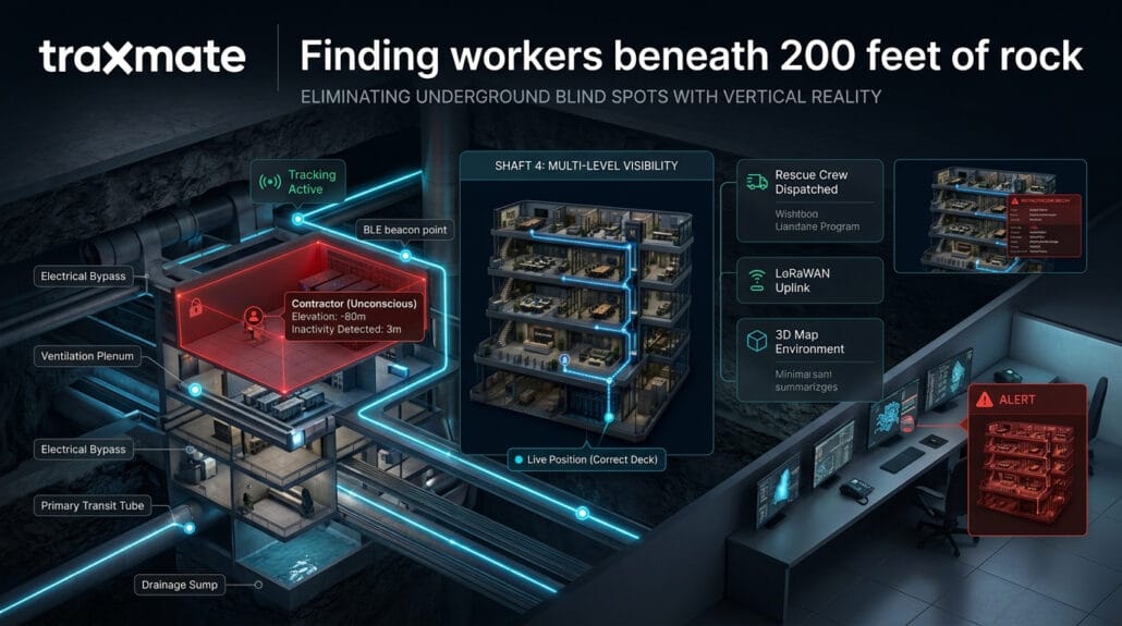
Subterranean worksites run blind by default. Standard satellite positioning stops working the moment a worker steps under reinforced concrete or solid rock. Control rooms typically try to manage this with 2 tools: manual badge swipes and static 2D prints.
Badge readers tell you someone entered the south portal at 06:45. They tell you that person never checked out at the surface. They do not tell you where that person is right now, whether they are standing up, or if they passed out 2 kilometers down an unlit haulage drift.
Flat prints make the problem worse. When you project an 8-level mining layout or a stacked subway interchange onto a two-dimensional plane, vertical reality vanishes. Different elevations pancake together. Dispatchers see coordinates, but they cannot see whether a team sits on the working deck or inside the crawl space 10 meters above it.
Radio check-ins help until someone cannot answer. If a lone technician working on a pump station collapses, he cannot speak into his radio. He cannot press an emergency button on his belt. He stays silent until a shift lead notices he missed a check-in call an hour later.
Fixed cameras help, but only where they look. Most subterranean systems contain thousands of meters of unmonitored utility runs, access ways, and service drifts. A camera on a platform cannot see into the electrical plenum 30 meters away.
Connecting tracking hardware to multi-level terrain
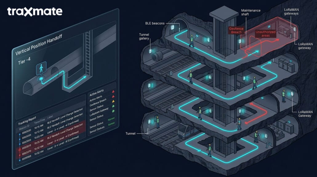
Fixing subterranean visibility requires 2 things: stable data transmission through concrete and rock, plus spatial visualization that reflects actual vertical depth. Traxmate provides this by combining multi-source device positioning with 3D map environments built for multi-tier facilities.
Instead of demanding line-of-sight satellite reception, the platform processes location data transmitted across private LoRaWAN networks. LoRaWAN radio signals cut through heavy stone and structural concrete across long physical distances. Battery-powered transmitters run for years without uninterrupted maintenance.
Within the tunnel galleries, the platform pairs these LoRaWAN packets with Bluetooth Low Energy (BLE) beacons fixed to tunnel ribs and Wi-Fi access points placed along transit corridors.
When a worker walks past a fixed BLE beacon, their worn tag catches the beacon ID and transmits the signal over the LoRaWAN link. The software handles these beacon signals to pinpoint the worker down to the exact crosscut, utility vault, or platform section.
When that worker climbs a vertical ladder between the lower transport tunnel and an upper ventilation plenum, the system tracks the level change.
Visualizing vertical space without the clutter
A coordinate string like 37.7749, -122.4194, Elev -45m means nothing to a dispatcher managing an active ventilation failure. They need visual reality.
Traxmate converts standard architectural plans and 2D CAD files into interactive 3D spatial models. Operators can spin the underground facility around, isolate specific vertical tiers, and strip away structural clutter. Dispatchers can view the entire underground volume on wall screens in the central control room.
If a worker triggers a call for help, their position appears in 3D. The software displays their location on the correct tunnel deck, next to the exact access ladder or refuge chamber. Rescue teams do not have to guess which deck to enter. They see the route before putting on their respirators.
The platform tracks movement history directly on the 3D model. If a crew working in a rail tube evacuates due to smoke, safety personnel watch the movement trail live on screen. They see if someone falls behind. They verify when every badge reaches the fresh-air base.
Automating rescue alerts for motionless workers
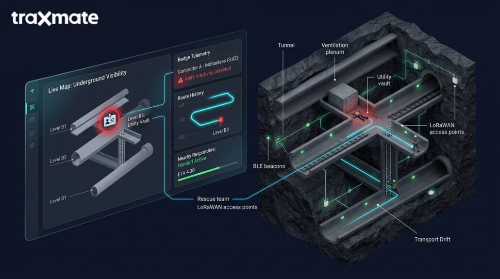
Emergencies underground rarely happen under ideal conditions. Workers rarely have time or the ability to call dispatch, explain their symptoms, and provide their coordinates. The system handles these events by tracking motion status directly from personal tags.
If a contractor remains completely still for 3 minutes inside an active haulage route or high-risk battery room, the platform registers an inactivity event. The platform flags the worker on the control room screen, sounds an audible alert, and triggers an automated notification to nearby team leads. The display shows the worker’s badge in bright red, right on the specific tunnel level where they stopped moving.
The same mechanism applies to perimeter security and blast safety. Tunnels contain zones where nobody should walk: high-voltage substations, areas beneath unsupported roofs, or faces loaded with explosives for an upcoming shift. Safety managers draw digital boundaries inside the 3D map to secure these areas. If an unauthorized worker crosses that boundary line, the tag vibrates to warn them to turn back. At the same second, dispatch sees the breach live on screen, identifying the person by name and exact position.
Breaking out of the camera silo with Milestone XProtect
Most heavy industrial sites, transit systems, and underground utilities run Milestone XProtect as their core video management system. It is the operational heart of the security operations center. The problem is that cameras show only what happens inside their narrow fields of view.
If an incident starts in front of Camera 12, moves down a cross-passage, and turns into an unmonitored utility gallery, the video wall goes black. The operator must switch mental models. They look away from the video wall, pull up a separate terminal, check an access control badge log, or scan radio chatter. That cognitive disconnect burns critical minutes during an escalation.
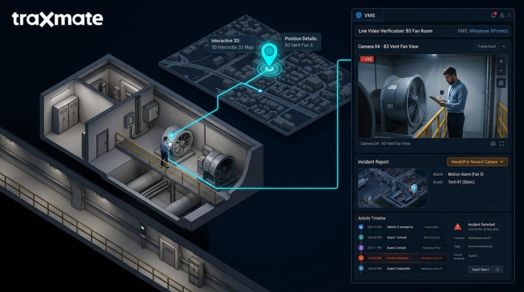
Traxmate integrates directly into Milestone XProtect Smart Client. It changes how control rooms use video. Instead of treating location data and video streams as 2 separate worlds, the Traxmate plugin injects live indoor tracking directly onto the XProtect interface. Operators stay in a single-screen environment.
When a lone worker icon moves down a haulage drift on the 3D map, the map sits right alongside the camera tiles inside Smart Client. If that worker enters the field of view of a fixed PTZ camera, the system automatically shows the camera feed. If the worker walks around a concrete bulkhead into a dark drift where no camera can see, the operator does not lose them. The tracking marker keeps advancing across the 3D geometry in real time. The operator sees the path, the direction of travel, and the exact distance to the nearest emergency telephone or ventilation station.
What Traxmate adds to an existing Milestone installation
If your facility already runs Milestone XProtect, you have invested heavily in camera hardware, recording servers, network switches, and operator training. Traxmate gives that existing investment an operational brain. Without real-time spatial tracking, an operator managing 400 camera feeds inside an extensive transit tunnel works reactively.
An alarm sounds somewhere in the ventilation loop. The operator must know which camera covers that specific damper, find the camera name in a nested tree directory of 400 devices, drag it onto a view tile, and hope the lens is clear. Traxmate eliminates that manual search. It maps every fixed camera in the facility into the shared 3D spatial coordinate space.
When a panic button triggers or an inactivity alarm sounds, Traxmate commands XProtect to display the nearest camera feed instantly. The system pulls the correct video view onto the operator’s workspace without a single click. The dispatcher sees live video and the exact 3D location marker at the same time.
Adding Traxmate to Milestone also introduces active trail playback. When investigating an incident after the fact, operators do not have to scrub through hours of footage across 15 different cameras to piece together where a contractor walked. They select the contractor’s badge ID in Smart Client and click playback. The platform draws the historical movement path across the multi-level 3D tunnel model. As the path advances, XProtect pulls the synchronized video clips recorded by every camera the worker passed along the route. Investigations that once consumed 2 days of manual video scrubbing now take 6 minutes.
What Milestone adds to Traxmate's spatial platform
Looking at the integration from the other direction reveals an equally powerful benefit.
Location tracking alone tells you where a dot is on a screen. It tells you Badge 402 is motionless at Level -3, Crosscut 14. It can’t tell you why that badge stopped moving. Did the technician drop his badge on the rail ballast? Did he step aside to eat lunch? Did a slab of rock fall from the ceiling and pin his leg?
Milestone XProtect provides the visual ground truth that gives tracking data immediate meaning. The moment Traxmate flags an inactivity alert at Crosscut 14, Milestone surfaces the closest optical and thermal video streams. The dispatcher glances at the video tile. They see clear air and a worker kneeling to inspect a junction box. False alarm. No sirens, no halt on rail traffic, no dispatch of the mine rescue team. Or they glance at the screen and see heavy smoke billowing down the drift with a person lying on the ground. Confirmed structural fire with an incapacitated worker. The supervisor sounds the full-facility evacuation siren instantly.
With visual confirmation in second 1, they don’t wait 10 minutes trying to reach the worker on a dead radio channel. They dispatch the emergency response team with exact situational clarity: they tell the team to bring breathing apparatus, hydraulic cutting tools, and a stretcher directly to Crosscut 14.
Mobile visibility with Axis body-worn cameras
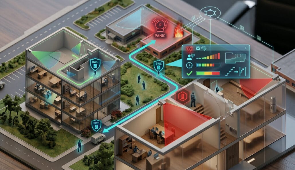
Fixed cameras leave massive visual gaps in subterranean environments. You cannot mount a fixed dome camera inside every utility crawlway, temporary blast heading, or maintenance shaft. That is why field crews wear Axis body-worn cameras.
Axis body-worn cameras feed live and recorded video straight into Milestone XProtect. Traxmate closes the final blind spot by tracking those body cameras across indoor and outdoor spaces.
As an emergency responder or tunnel inspector moves deep into unmonitored shafts, their Axis body camera scans ambient Wi-Fi access points and fixed BLE beacons while streaming telemetry. Traxmate resolves those signals into precise room and floor coordinates and feeds the position into Milestone Smart Client. The control room supervisor sees the officer’s live badge icon moving through the 3D tunnel model.
Right next to that 3D marker, they watch the officer’s first-person video stream in real time. If the officer comes across an unexpected structural crack or a failing water pipe, command staff see exactly what the officer sees. More importantly, command staff know the officer’s exact location, the elevation they stand on, and the fastest escape route behind them. If the officer falls or comes under duress, they don’t have to struggle to explain their position over an echoey radio. Their coordinates and video feed are locked together in the control room interface.
Achieving unified situational awareness
True operational control requires removing the friction between software tools. When an emergency unfolds 100 meters underground, supervisors cannot juggle 4 disconnected computer applications. They cannot look at a CAD drawing on one monitor, a video matrix on a second monitor, an access control table on a third, and a radio dispatch console on a fourth.
Fusing Traxmate’s 3D positioning with Milestone XProtect brings all 4 functions into a single operational canvas:
- Spatial reality: 3D maps display every person, vehicle, and piece of equipment across every horizontal drift and vertical shaft in true depth.
- Visual confirmation: Fixed cameras and Axis body-worn cameras verify incidents within seconds, removing ambiguity from sensor alarms.
- Automated response: Geofence breaches and motionless-worker alerts automatically trigger camera switching and emergency notifications.
- Coordinated dispatch: Rescue teams move with certainty because dispatchers see the entire facility in 3 dimensions and guide responders around hazards directly to the target.
The operational dividend of real visibility
Operating underground without continuous indoor tracking is a deliberate gamble.
You hope workers keep their radios handy.
You hope people stay out of restricted shafts.
You hope your dispatchers can translate a flat 2D blueprint into actual search instructions during a fire.
Replacing that guesswork with real-time 3D tracking and video integration changes the operational baseline:
- Search times drop to seconds: Emergency responders walk straight to the right level, crosscut, and access door.
- Muster audits happen instantly: During emergency evacuations, the system tallies headcount automatically as personnel reach safe zones or surface portals. Nobody sends search parties back underground for someone who already cleared the turnstile.
- Contractor oversight becomes transparent: Facility managers verify where maintenance teams spend their shift hours without stationing escorts at every bulkhead.
- Hazard zones stay clear: Automated perimeter alerts keep people away from blast zones, toxic exhaust corridors, and energized switchgear.
- Video surveillance gains operational purpose: Cameras become active, location-guided response tools inside Milestone XProtect.
Underground safety comes down to knowing where people are when the environment turns hostile. Putting multi-level 3D maps, continuous LoRaWAN tracking, and unified Milestone video into your control room gives your operators the insight they need to keep workers safe.